
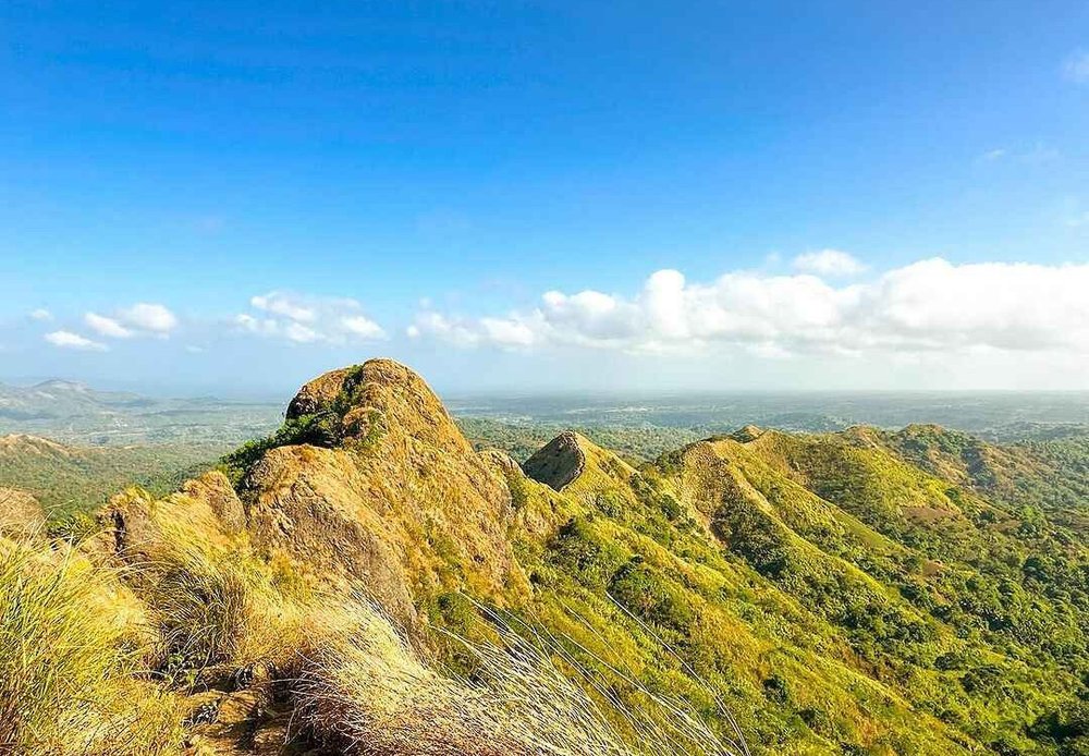
Mt. Batulao is one of the most recognizable hiking destinations in Batangas, especially for hikers looking for a rewarding mountain adventure near Manila. Located in Nasugbu, the mountain is famous for its open grassland ridges, dramatic views, and a series of twelve peaks that make the climb both challenging and visually rewarding.
Standing at 811 meters above sea level (MASL), Mt. Batulao offers a combination of rolling trails, exposed ridgelines, steep sections, and rope-assisted descents. While the mountain is often described as beginner-friendly, that description needs an important qualification: the New Trail is suitable for beginners, while the Old Trail contains steep and technical sections that are better suited to experienced hikers.
Before planning your trip, it is also worth reviewing this detailed Mt. Batulao MASL, difficulty, hike, height, and location guide for another quick reference to the mountain’s essential hiking information.
Mt. Batulao Quick Facts
| Information | Details |
|---|---|
| Mountain | Mt. Batulao |
| Location | Barangay Don Bosco, Nasugbu |
| Province | Batangas |
| Region | CALABARZON |
| Elevation | 811 MASL |
| Difficulty | Minor to Moderate, depending on trail |
| Jump-off Point | Barangay Don Bosco, Nasugbu |
| Recommended Season | November to February |
| Full Traverse | Around 6–8 hours |
| Registration Fee | PHP 200 per person |
| Main Routes | New Trail and Old Trail |
Where Is Mt. Batulao?
Mt. Batulao is located in Nasugbu, Batangas, approximately 90 kilometers from Metro Manila. The mountain stands near the Batangas-Cavite boundary and is easily recognizable from portions of the Tagaytay-Nasugbu Highway because of its distinct series of grassy peaks.
Unlike heavily forested mountains, Mt. Batulao is characterized by an open cogon-covered landscape. Its exposed ridgeline creates sweeping views throughout much of the hike, making the trail particularly appealing to photographers and hikers who enjoy panoramic scenery.
The mountain rises to 811 MASL, with its summit offering views toward Taal Lake, Balayan Bay, and the surrounding countryside.
Because of its relatively accessible location from Metro Manila, Mt. Batulao has become a popular option for weekend hiking trips.
How to Get to Mt. Batulao From Manila
Traveling to Mt. Batulao from Manila is relatively straightforward, especially when leaving early in the morning.
One common option is to take a provincial bus bound for Nasugbu or Balayan from either the LRT Buendia Terminal in Pasay or PITX.
The bus fare in the provided trail information is approximately PHP 169 one way. Ask the driver or conductor to drop you at KC Hillcrest Golf Course, formerly known as Evercrest, along the Tagaytay-Nasugbu Highway.
From the entrance, hikers can take a motorized tricycle to the trailhead, with the provided fare listed at around PHP 40.
For hikers bringing their own vehicle, parking is available near the jump-off point. The listed parking rates are approximately:
- PHP 100 for four-wheeled vehicles
- PHP 25 for motorcycles
Because transportation schedules and fares can change, hikers should always confirm current rates before departure.
Mt. Batulao Registration Fee and Guide Fee
One of the most important things to know before climbing Mt. Batulao is that the registration fee is collected in different stages.
The total registration cost for a full traverse is listed at PHP 200 per person:
| Checkpoint | Fee | Purpose |
|---|---|---|
| Primary Jump-off Kiosk | PHP 140 | Barangay eco-fee and municipal tourism tax |
| Camp 8 | PHP 20 | Private land passage fee |
| Old Trail Descent Junction | PHP 40 | Trail boundary/traverse fee |
| Total | PHP 200 | Full traverse |
The staggered collection can surprise first-time hikers, so it is a good idea to keep smaller bills available throughout the hike.
A local guide is also mandatory according to the supplied trail information. The listed day-hike rate is PHP 800 per group of up to five hikers, while the overnight guide fee is PHP 1,200.
For a group of five, the day-hike guide cost works out to about PHP 160 per person.
Registration is described as walk-in, with no advance booking system and no daily crowd cap. During busy weekends, this can contribute to longer waiting times at narrow trail sections.
What Is the Mt. Batulao Trail Like?
The full Mt. Batulao circuit covers approximately 12 kilometers and includes two main routes: the New Trail and the Old Trail.
These trails offer very different hiking experiences, which is why understanding the route before your climb is important.
New Trail: The Better Option for Beginners
The New Trail is the more gradual route and is generally the recommended choice for first-time Mt. Batulao hikers.
The trail passes through open grassland and a series of numbered peaks. The gradual climbs and wider sections make it easier to maintain a steady pace compared with the technical portions of the Old Trail.
Camp 8, located at around 679 MASL, serves as an important rest and registration point. From there, hikers continue toward the higher sections and eventually reach Peak 12, the 811-MASL summit.
The approximate difficulty progression on the New Trail is:
| Section | Difficulty | What to Expect |
|---|---|---|
| Peaks 1–3 | 2/5 | Gentle inclines and wide trail |
| Peaks 4–6 | 3/5 | Increasing gradient and strong sun exposure |
| Peaks 7–8 | 3/5 | Narrower ridges and loose soil |
| Peaks 9–11 | 4/5 | Steeper and more sustained climb |
| Peak 12 | 3/5 | Final summit approach |
The main challenge on this route is not technical climbing but heat, sun exposure, and sustained uphill walking.
For hikers who want to build confidence before tackling Mt. Batulao, a shorter nearby climb such as Mt. Talamitam in Nasugbu can also be a good addition to a Batangas hiking itinerary.
Old Trail: Steeper and More Technical
The Old Trail offers a significantly different experience.
Instead of mainly rolling terrain, hikers encounter steep sections assisted by fixed nylon ropes, with some inclines reaching approximately 60 to 70 degrees according to the supplied guide.
The terrain can include loose volcanic soil, steep drops, and sections where hikers need to carefully use both their hands and feet.
This means the Old Trail is not the best choice for inexperienced hikers. Good footwear, confidence on steep terrain, and proper guidance are particularly important.
The commonly recommended route is:
New Trail going up + Old Trail going down
This route allows hikers to tackle the gradual ascent first before dealing with the more technical descent.
Is Mt. Batulao Beginner-Friendly?
The answer depends entirely on which trail you take.
Calling Mt. Batulao simply “beginner-friendly” can be misleading.
The New Trail is accessible to fit beginners, especially hikers who are prepared for sun exposure and several hours of uphill walking.
The Old Trail, however, requires greater caution because of its steep rope sections and loose terrain.
First-time hikers should therefore discuss their route with their local guide and avoid assuming that the entire mountain has the same level of difficulty.
For more beginner-oriented hiking ideas, check this guide to beginner-friendly minor hikes for alternative mountains that may be easier to manage.
Best Time to Hike Mt. Batulao
The recommended period for climbing Mt. Batulao is November to February, when temperatures are generally more comfortable and the exposed ridges are easier to handle.
Although the dry season extends into the warmer months, March to May can be particularly hot, especially because much of the trail has little to no shade.
The supplied May 2026 hiking experience highlighted heat as one of the major challenges during the climb.
For a more comfortable hike, an early start is strongly recommended.
Avoiding Crowds
Mt. Batulao can become extremely busy during weekends, holidays, and other peak periods.
Crowded conditions can mean:
- Longer queues at rope sections
- Slower movement on narrow ridges
- Longer waits near the summit
- Less peaceful views and photography opportunities
Weekday hikes are generally more attractive for hikers who prefer a quieter experience.
During the rainy months from June to October, extra caution is necessary. Wet soil can become slippery, particularly along the steep portions of the Old Trail.
It is also wise to check weather conditions before your trip using the PAGASA weather service.
Mt. Batulao Hiking Budget
Your total cost will depend on whether you travel alone, with a group, or with your own vehicle.
Based on the supplied trail information, the following are useful budget figures:
| Expense | Estimated Cost |
|---|---|
| Bus from Manila, one way | PHP 169 |
| Tricycle to trailhead | PHP 40 |
| Registration | PHP 200 |
| Guide, per person in a group of 5 | PHP 160 |
| Guide, solo/pair | PHP 800 total |
| Parking, four-wheeled vehicle | PHP 100 |
| Parking, motorcycle | PHP 25 |
| Camping fee | PHP 30 |
| Tent rental | PHP 350 |
| Wash-up | PHP 25 |
| Trail food and drinks | PHP 100–200 |
| Batangas lomi | PHP 60–80 |
A comfortable day hike can be budgeted at approximately PHP 1,000–1,200 per person, including transportation from Manila and back.
For an overnight trip, the estimated budget can reach around PHP 1,400–1,600, particularly if you need to rent a tent.
These figures are guides rather than fixed rates, so it is best to confirm current fees with the local registration area before hiking.
What to Bring to Mt. Batulao
Mt. Batulao’s open terrain means sun protection and hydration should be priorities.
Recommended essentials include:
Hiking shoes or boots with good traction
The loose soil and steep sections of the Old Trail require dependable grip.
At least 3 liters of water
There are no reliable natural springs along the upper sections, and the exposed trail can become very hot.
Long-sleeved clothing
A lightweight UV-protective shirt can help reduce sun exposure.
Trekking gloves
These are particularly useful for rope-assisted sections.
Hat and sunscreen
Much of the trail is exposed to direct sunlight.
Trekking poles
Useful for balance, particularly on steep or loose terrain.
Headlamp
Important for pre-dawn starts and overnight hikes.
Snacks and packed food
Bring enough food for the duration of the hike rather than relying entirely on trail vendors.
Basic first-aid supplies
A small first-aid kit should always be part of your hiking gear.
Proper footwear is especially important. Shoes with shallow soles can become problematic on loose terrain, so hikers should choose footwear with sufficient traction.
Mt. Batulao Safety Tips
Mt. Batulao should not be underestimated simply because it is close to Manila.
The combination of heat, exposed ridges, steep sections, loose soil, and crowds can make the hike more demanding than expected.
Before leaving the jump-off, make sure your group has enough water and understands the route.
It is also advisable to save emergency contact numbers before the hike. The supplied guide lists the following:
MDRRMO Rescue Nasugbu:
+63 917 508 9911
+63 919 629 2599
Nasugbu Police Station:
+63 927 500 1199
+63 998 598 5698
Philippine Coast Guard Nasugbu:
+63 915 043 9693
National Emergency Hotline:
911
Starting early is another important safety measure. An early departure reduces the amount of time spent hiking under the strongest midday sun.
Campfires are also prohibited across the mountain because the dry grassland environment creates a fire risk.
Where to Stay Before or After Hiking Mt. Batulao
For hikers who want to arrive early or avoid traveling from Manila on the same morning, staying near the mountain can make the trip more convenient.
The supplied guide identifies KC Hillcrest Hotel in Barangay Kaylaway as one nearby lodging option, approximately 1.21 kilometers from the jump-off area.
During peak weekends, advance accommodation planning is recommended.
Other Mountains to Explore Near Mt. Batulao
One of the best things about hiking in Batangas and nearby Cavite is the number of mountains that can be combined into a single adventure.
For a more ambitious weekend, the Nasugbu Trilogy itinerary combines Mt. Batulao, Mt. Talamitam, and Mt. Apayang into a multi-mountain experience.
You can also explore the dedicated Mt. Apayang hiking guide if you want a quieter companion climb.
For hikers heading toward Cavite, Mt. Marami in Maragondon offers another grassland-style adventure, while Mt. Lantik is another option for those looking to explore lesser-known mountains in the area.
These destinations make it possible to turn a simple day hike into a longer weekend adventure around Southern Luzon.
Mt. Batulao remains one of the most appealing hiking destinations near Manila because it combines accessibility with rewarding mountain scenery.
Its 811-MASL summit, twelve peaks, open ridgelines, and panoramic views make the experience memorable, but hikers should not confuse accessibility with ease.
The New Trail makes the mountain manageable for fit beginners, while the Old Trail demands considerably more confidence and careful movement. Understanding that difference is one of the most important things to know before your climb.
With the right preparation, an early start, sufficient water, suitable footwear, and a reliable local guide, Mt. Batulao can be an excellent weekend adventure for hikers exploring Batangas and Southern Luzon.